
All rights reserved to the presidency Copyright © 2020


Western North Coast Development Project is the third national project of the series of national projects for development nationwide set by the National Strategic Plan for Urban Development 2052, in which the government has taken serious steps in the recent period, the first is development project in the Suez Canal area and then the golden triangle of mining in the Eastern Desert.
The project coincides with the plan implemented by the government for future boundary delimitation of the governorates and for providing development and investment opportunities and the establishment of new urban communities to accommodate the expected population increase in the coming decades, which included the addition of three new governorates; Central Sinai, El-Wahat (El-Wahat el-Bahariya and Al-Farafra), El-Alamein (El-Alamein, El-Dabaa, and Fuka in Matrouh).
The western part of the North Coast extends from El-Alamein to El-Salloum to a distance of about 500 km, with a depth of more than 280 km, extending over an area of 160 km2
The importance of this development domain is attributed to its uniqueness and excellence in that it has all the resources and elements of development distributed throughout the Republic, to concentrate in one place is the North West Coast and the Sahara desert.
The western part of the North Coast region, with its various resources, is the hope of Egypt to absorb the population growth over the next 40 years, which is estimated at 34 million people. The projects to be implemented will provide about 11 million jobs opportunity up to the year of 2052.
The development of the western part of the North Coast aims to achieve economic growth, which is the goal of all projects adopted by the state for a better future for the coming generations.
Among the most important strategic objectives of the western part of the North Coast are achieving a high economic growth rate of not less than 12% annually, settling at least 5 million people and providing about 1.5 million jobs in addition to integrating the region in the national and global economy and by increasing their contribution to the GDP from 5% to 7%.
This project aims to improve social and living conditions of local communities so that the human development index will not be less than 77%, develop infrastructure networks and strengthen exchange relations between the area of study and other surrounding regions.
The proposed developmental thinking for this project is based on the optimal use of all resources and components in this area. This is represented in masking use of the areas south of the coastline from El-Alamein to El-Salloum in land reclamation based on rainwater and groundwater, the development of existing coastal cities as main development centers, the establishment new urban clusters based on tourism, residential, agricultural industry and mining activities after agricultural reclamation. This is in addition to establishing a number of new environmental groups to serve the safari tourism activities and the reclamation of millions of acres for the desalination of sea water and agricultural drainage water treatment for the cultivation of bio-fuel and fodder plants, along with the exploitation of the Qattara Depression in the integrated development.
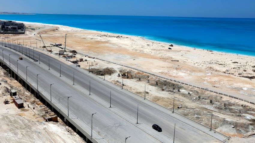
The road network is among the most important components of the success of this third national project since roads are a means to achieving development as confirmed by the Minister of Housing. He pointed out that they began working on several axes for connection between the urban centers and the rest of the country, especially in Upper Egypt. This is included in the National Road Plan that the government started to implement.
On top of these axes comes the Qattara Depression Axis from the Cairo-Alexandria Road in the east at a length of 220 km to Ras Al-Hikma and its sub-links to Al-Barqan, El-Hamam, El-Alamein, El-Dabaa and Fuka. This is in addition to linking the area to the governorates of Upper Egypt through a network of axes: El-Bahnasa axis (Minya) - El-Wahat el-Bahariya - Siwa – Al-Jaghbub at the Libyan border, Assiut - Farafra - Ain Dalla (Dalla Spring) - Siwa.
The North West Coast Development Project is the gateway to new operational mechanisms to address water and energy scarcity issues through various approaches, ideas and operational tools through the use of new and renewable solar energy resources to be generated in this range; the second area that has the highest sunshine record in the country. The same goes via nuclear energy, especially after starting to take the necessary measures for the establishment of the nuclear reactor in Dabaa. The new and renewable sources of energy will be directed to desalination of seawater for different development uses, thus achieving self-sufficiency for implementing this project.
In terms of land reclamation and agricultural development, the area is rich in groundwater resources in the desert, with coastal areas that collect rainwater and a source of irrigation from the Nile through El-Hamam Canal to reclaim and plant about 148,000 feddans and remove the obstacles.
About 150,000 feddans in Moghara area, nearly 50,000 feddans in the south of the Qattara Depression and 30,000 feddans in Siwa are planned to be planted, providing an agricultural plot distributed throughout the desert based on groundwater and irrigation resource.
As to tourism development, the region contains many extractive resources that ensure the establishment of many industries on which it is based, whether mainly or secondary. The most important resources are: High and medium purity limestone, clay, bentonite, dolomite, gypsum, quartz sand. Such resources are essential for making construction materials. There is also high-purity rock salt at Qattara Depression that has high economic and oil exploration and extraction areas at Qattara Depression as well as explorations of crude oil and natural gas.
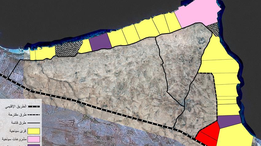
The plan includes the development of a number of new cities, including El-Alamein City to be the first of the fourth-generation new cities in Egypt. New El-Alamein City is one of the most important cities that reflect integrated development in the North West Coast and Qattara Depression.
A presidential decree was issued to establish New El-Alamein, an 88,000 feddan area located about 10 kilometers from the coast. It will be the icon of development in the North coast. It is a city of distinct urban environmental character, south of the coastal road.
The city is a fourth-generation new city, which rely on renewable energy sources, having been cleared of mines. 15,000 feddans are available for the immediate development of the city.
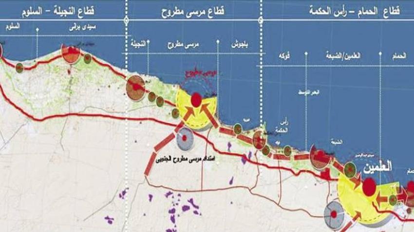
The western part of the North Coast region includes many types and attractions for beach tourism, along the northwestern coast of about 400 km, west of Alexandria, to the western border of the republic with a length of about 90 km west of Alexandria to El-Alamein, from El-Alamein to Ras Al-Hikma with a length of 130 km, from Al-Najila to El-Salloum also with a length of about 130 km, which includes about 90 km, east and west of Marsa Matruh.
Therapeutic tourism is located in the sands of the Siwa Oasis, and ecotourism within the reserves of Omayed, Siwa and El-Salloum, as well as safari tourism, which extends from the White Desert to the El-Wahat El-Bahariya, through the sand dunes of the Western Desert, to Siwa Oasis area, Safari from El-Alamein - Ras Al-Hikma - Sidi Barrani – El-Salloum.
It contains cultural and historical attractions of the Commonwealth and the Italian and German Cemeteries. The area was marked by World War II battlegrounds, El-Alamein Military Museum, the Rummel Museum, a group of Pharaonic tombs and temples in Cleopatra. In the desert in Old Shali in Siwa Oasis. This type of tourism encourages the establishment of tourism festivals and celebrations in those areas, in response to the historical events that took place in these areas.
- The first project is to connect the Sadat City with the Cairo-Alexandria agricultural road with a length of about 16 km, including the implementation of 12 industrial works and 4 overhead bridges, in addition to the implementation of 8 surface bridges and 5 walkways.
The agency explained that the aim of this project is to move the traffic between (Cairo / Alexandria) agricultural road and the industrial city of Quweisna in the east in the Sadat City road and then to (Cairo / Alexandria) desert road in the west.
- The second project: According to the plan of the agency in the implementation of the first phase of Abou El Rous / Metobas / Fowa with a length of about 34 km and a width of 21 meters in two directions, each direction has 3 traffic lanes and a middle island with the aim of moving directly from the international coastal road and the governorates of Kafr El-Sheikh and Beheira to serve the areas of fish farms and agricultural areas, as well as the new industrial zone in Metobas.
- The third project: It is represented in the plan of the Rehabilitation Authority of the coast in purifying and deepening Lake Burullus as a first phase through the removal of the pond from the lake area of 1395 feddans in order to solve the problems of the lake and regain its role as a major source of fish wealth.
The fourth project consists of the implementation of the circular road, west of El-Gamaleya with a length of about 2.7 km and a width of 17 meters, including the work of a surface bridge and a railway crossing to transport heavy traffic between the production centers in the governorates to Damietta port directly without passing through the residential block of Al-Gamaliyah city.
The two projects of the Western North Coast Reconstruction Authority are represented in the implementation of the Siwa/El-Wahat El-Bahariya Oasis Road with a length of 360 km and a width of 11 meters, with the aim of benefiting from arable land, linking Siwa Oasis El-Wahat El-Bahariya as well as El Wadi El Gadid axes and Cairo. This is in addition to encouraging safari and therapeutic tourism.
The second project of the Western Reconstruction Agency is to raise the efficiency and development of the Siwa/ El-Wahat El-Bahariya Road at the length of 110 km in order to connect Qara Oasis to Matrouh / Siwa road, develop the areas on both sides of the road, and benefit from the mineral water available in the oasis.
Detailed data for the Western North Coast tourism sector
Sector Area (m2):
- Total area: 1,509,277,814.86
- Planned area: 79,970,000
- Approved area: 9,316,502
- Area under construction: 2,159,030
- Implemented Area: 3,957,162
Detailed data of Markaz Bagush - Ras Hawala
- Area: (m2):
- Total area: 3,471,903.86 (m2)
- Planned area: 52,830,00 (m2)
- Approved area: 9,316,502 (m2)
- Area under construction: 2,159,030 (m2)
- Implemented Area: 3,957,162 (m2)
Detailed data of Markaz Ras Al-Hikma
- Area: (m2):
- Total area: 154,170,311 m2
- Planned area: 27,140,000 m2


All rights reserved to the presidency Copyright © 2020
All rights reserved to the presidency Copyright © 2020