
All rights reserved to the presidency Copyright © 2020


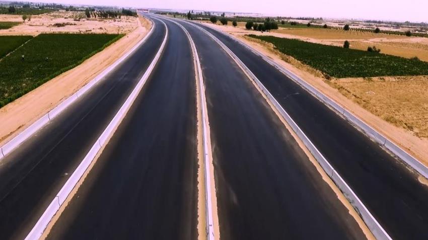
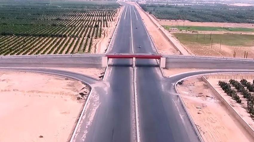
President Abdel Fattah El-Sisi witnessed the opening of the 30 June axis with a length of 210 km, parallel to the Suez Canal. It is one of the mega national projects that the state is inaugurating during the recent period within the comprehensive development plan. It consists of two directions, each direction is consisting of 5 traffic lanes, 2 lanes for heavy transport and 3 lanes for other vehicles. It also includes industrial works from the 5th km, the international coastal road to the 94th km of Cairo / Ismailia Desert Road, passing through the following major intersections: The road linking the southern Port Said tunnel - Shader Azzam road (Al-Salam Canal) - Al-Qantara / Al-Salihiya road - Al-Fardan / Salhiya road - Road 36 Al-Harbi - Ismailia / Zagazig Agricultural Road (Ismailia Canal - Ismailia / Zagazig Railway).
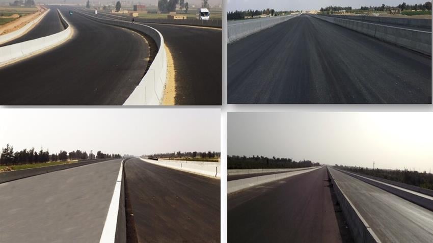
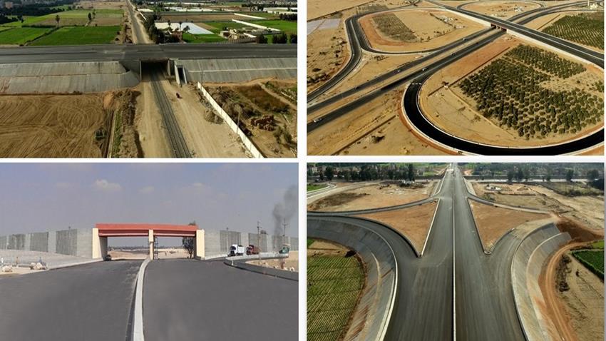
It includes a number of industrial works and includes 6 vertical bridges on the axis, 14 main bridges in the direction of the axis, 24 pedestrian and cars tunnels, 2 pedestrian tunnels, 400 solar lighting columns on bridges, and 2 points to secure the road. The role of the axis has roles at the national and local levels.
First, at the national level:
• Enhancing interconnection and communication between 4 development regions (Suez Canal, Delta, Cairo and Red Sea).
• Contributing to increasing the Egyptian population by providing new development opportunities.
• Achieving balance regarding population redistribution.
• Achieving social justice and geographical distribution of resources.
• Achieving interconnection between major national projects (the administrative capital, the axis of the Suez Canal development).
• Bridging the developmental and urban gap in the region between East Delta and West Canal.
• Contributing to achieving the comprehensive development vision for Sinai, which depends on transferring and linking development opportunities from the west of the canal to the east and the launch of development in the Sinai from west to east.
• Playing an important role at the regional level, through achieving functional linkages between the governorates of the Suez Canal region.
• Achieving the desired goals of the spatial distribution pattern and functional composition of 5 fourth generation cities in different stages of development in an integrated regional framework (Salam, West Port Said, New Ismailia, New Suez, Galala).
• Activating the internal trade movement in the region by linking the two areas of development north and south of the Suez Canal development axis.
• Enhancing interconnection and communication between the ports of the Red Sea (Ain Sukhna - Al-Adabya- Suez) and the Mediterranean (Al-Arish - East Port Said - Port Said - Damietta - Alexandria).
• Doubling the export capacity of agricultural and industrial products.
Second, at the local level:
• Reducing the travel time between the Canal's cities.
• Increasing the safety factor and reducing accident rates.
• Achieving the competitive advantage of lands around the axis and maximizing their economic value.
• Creating new developmental nuclei on both sides of the axis linked to the vertical movement axes on it (6 orthogonal axes).
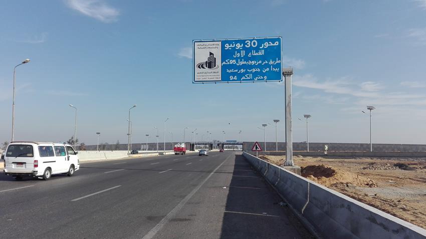
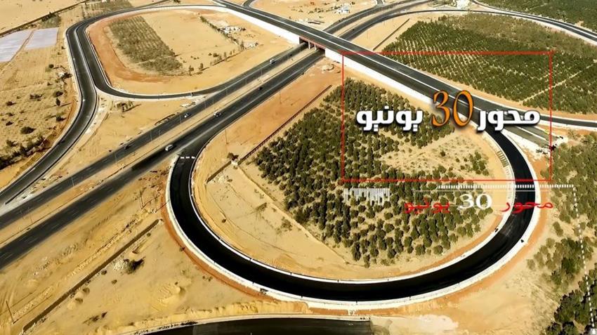
President Abdel Fattah El-Sisi witnessed the opening of the 30 June axis with a length of 210 km, parallel to the Suez Canal. It is one of the mega national projects that the state is inaugurating during the recent period within the comprehensive development plan. It consists of two directions, each direction is consisting of 5 traffic lanes, 2 lanes for heavy transport and 3 lanes for other vehicles. It also includes industrial works from the 5th km, the international coastal road to the 94th km of Cairo / Ismailia Desert Road, passing through the following major intersections: The road linking the southern Port Said tunnel - Shader Azzam road (Al-Salam Canal) - Al-Qantara / Al-Salihiya road - Al-Fardan / Salhiya road - Road 36 Al-Harbi - Ismailia / Zagazig Agricultural Road (Ismailia Canal - Ismailia / Zagazig Railway).
It includes a number of industrial works and includes 6 vertical bridges on the axis, 14 main bridges in the direction of the axis, 24 pedestrian and cars tunnels, 2 pedestrian tunnels, 400 solar lighting columns on bridges, and 2 points to secure the road. The role of the axis has roles at the national and local levels.
First, at the national level:
• Enhancing interconnection and communication between 4 development regions (Suez Canal, Delta, Cairo and Red Sea).
• Contributing to increasing the Egyptian population by providing new development opportunities.
• Achieving balance regarding population redistribution.
• Achieving social justice and geographical distribution of resources.
• Achieving interconnection between major national projects (the administrative capital, the axis of the Suez Canal development).
• Bridging the developmental and urban gap in the region between East Delta and West Canal.
• Contributing to achieving the comprehensive development vision for Sinai, which depends on transferring and linking development opportunities from the west of the canal to the east and the launch of development in the Sinai from west to east.
• Playing an important role at the regional level, through achieving functional linkages between the governorates of the Suez Canal region.
• Achieving the desired goals of the spatial distribution pattern and functional composition of 5 fourth generation cities in different stages of development in an integrated regional framework (Salam, West Port Said, New Ismailia, New Suez, Galala).
• Activating the internal trade movement in the region by linking the two areas of development north and south of the Suez Canal development axis.
• Enhancing interconnection and communication between the ports of the Red Sea (Ain Sukhna - Al-Adabya- Suez) and the Mediterranean (Al-Arish - East Port Said - Port Said - Damietta - Alexandria).
• Doubling the export capacity of agricultural and industrial products.
Second, at the local level:
• Reducing the travel time between the Canal's cities.
• Increasing the safety factor and reducing accident rates.
• Achieving the competitive advantage of lands around the axis and maximizing their economic value.
• Creating new developmental nuclei on both sides of the axis linked to the vertical movement axes on it (6 orthogonal axes).
It is divided into two parts:
• The first part: It consists of 6 traffic lanes + a road track + a service road with a total width of 80 meters.
• The second part: It consists of 3 car lanes + 2 truck lanes + service road in each direction.
It consists of 4 traffic lanes and a changing central island.
- 6 vertical bridges on the axis.
- 14 main bridges in the direction of the axis.
- 24 pedestrian and cars tunnels.
- 2 pedestrian tunnels.
- 400 solar street lights.
- 2 charging stations to secure the road.
- 50 national contracting companies specialized in the field of roads, bridges and surface planning participated in the implementation of the project, with 75 thousand workers and engineers, using 3500 engineering equipment.
- 30 million m^3 of backfilling.
- 10.5 million m^3 drilling works.
- 1 million m^3 dredging works.
- 600 thousand m^3 layers of rubble backfilling.
- 60 thousand linear meters of deep foundations.
- 17 million m^2 of asphalt.
- 200 points monitoring the northern sector's landing pressure.
- 10 million m^2 of industrial textile layers (reinforcing soil works using "Geotextile / Geogrid" industrial textile fibers).
- Drying fish farms on the axis track and the road with a length of 22 km and a width of 100 meters on both sides of the axis.


All rights reserved to the presidency Copyright © 2020
All rights reserved to the presidency Copyright © 2020